

Governor Kemp Declares State of Emergency Ahead Of Helene
 |
|
The National Weather Service in Peachtree City has provided an update on possible impacts of Tropical Storm Helene as it enters Georgia later this week.
|
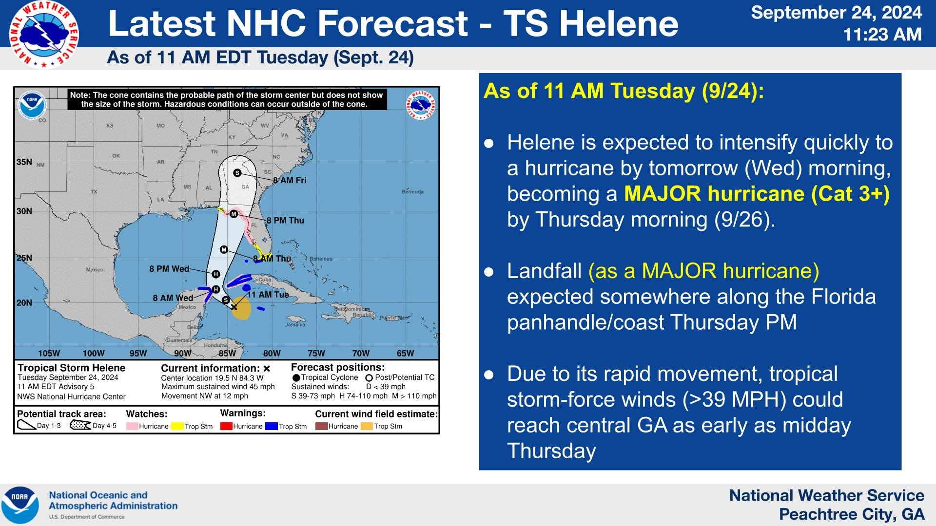
During the 11 a.m. update from the National Hurricane Center Potential Cyclone #9 had formed into Tropical Storm Helene. The storm is expected to move into the warm waters of the Gulf of Mexico and intensify quickly to a possible Category 3 hurricane with winds of up to 115 mph or possibly greater by the time it makes landfall some time on Thursday in Florida, where storm surge of up to 15 feet in some areas is forecast. Residents from Panama City to Cedar Key are on alert for a possible direct hit from Helene.
The storm is expected to move north into Georgia and bring statewide impacts including to the Chattahoochee Valley. Ahead of the possible storm and its impacts state officials are getting ready for storm and urging residents to prepare now.
On Tuesday afternoon, Georgia Governor Brian Kemp issued a State of Emergency for all 159 Georgia counties. The State of Emergency will free up state resources to assist in the aftermath of the storm.
Helene is expected to hit Florida as a major hurricane on Thursday evening and track into Georgia. Once in Georgia the storm is expected to begin to weaken but is projected to maintain Tropical Storm strength as it moves northward through the state. Impacts in Georgia are expected to include gusty winds, heavy tropical downpours and few tornadoes mostly on the eastern sides of the storm. Flooding is a risk as rainfall totals of four to eight inches are expected across the state with some isolated higher totals. An unassociated rain event is expected to impact areas across the state Wednesday that could drop heavy rain and possibly add to the flooding risk ahead of Helene's impacts.
GEMA PREPARATION
At 3 p.m. on Tuesday, September 24, 2024, Georgia Emergency Management Director Chris Stallings held a media briefing ahead of the storm. In the briefing Director Stallings said that equipment and personnel have been prepositioned to address emergencies as they may arise.
During the briefing he did mention that the impacts of the storm are expected to be felt statewide and this will be a different event than Hurricane Debby, which brought flooding rains to portions of southeast Georgia earlier this summer. That storm was a very slow moving storm, while Helene is expected to move across the state quickly with rain beginning on Wednesday evening in parts of South Georgia. Areas of Central Georgia should begin to see impacts early Thursday with heavy rain and high winds. The impacts are expected to exit late Friday.
In addition Director Stallings says this storm will have significant wind with it as tropical storm force winds could be felt statewide including into the north Georgia mountains. The Columbus area is expected to sit to the west of the center of the storm meaning the area will not see the strongest impacts like what will be seen on the eastern area of the storm which will past just east of the area according to the latest projected path.
The anticipation of the high winds are expected to bring down trees and powerlines across a large area of the state, which will result in widespread power outages. Stallings says the storm is expected to have a large wind field with tropical storm force winds extending out from the center of the storm.
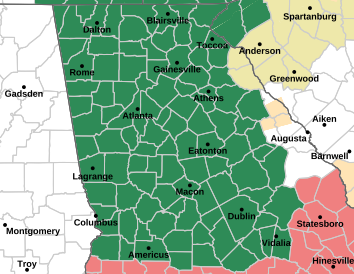 |
A flood watch has been issued for a large portion of Georgia including the Columbus area. The flood watch runs from Wednesday afternoon until Friday afternoon. |
"In most of our storms we have generalized locations where we can bring in resources within the state, unfortunately because this is a statewide event we fully anticipate that our resources are going to be scattered all throughout the state. So we have started reaching out through EMAC to bring in state partners from other states and resources as needed," said Stallings, "It is extremely important to understand that takes time so if you lose power or your water goes out its not going to be a quick turnaround because we are having major outages statewide."
Ahead of the expected storm impacts Director Stallings says now is the time to prepare. This includes having a charged mobile device and a backup power source. It is also encouraged to have a family preparedness kit.
The impacts of Helene are still changing as the storm develops. Forecasters are now getting a better take on what the storm may have in store and how it will impact areas. Be sure to stay with The Chattahoochee Voice as we bring any new updates we may receive ahead of Helene arriving into Georgia and Alabama.
Read The Full State of Emergency Here